Angora Hiking Club
Astoria, Oregon
Archives – Badge – Sign-up – Apply
100 years – Goat – Photos – Songs
History – Documents 1921, 2018, 20
9 March
1:00 p.m.
led by Jaime McDermott & Rachel Jensen of the
Lower Columbia Preservation Society
Meet in the LCPS office: corner of 12th and Duane Streets.
Visit the LCPS website and consider becoming a LCPS member.
Find an excellent illustrated article of the walking tour here.
16 March
1:00 p.m.
led by Xia Amendolara
503-553-9900
19 March
9:00 a.m.
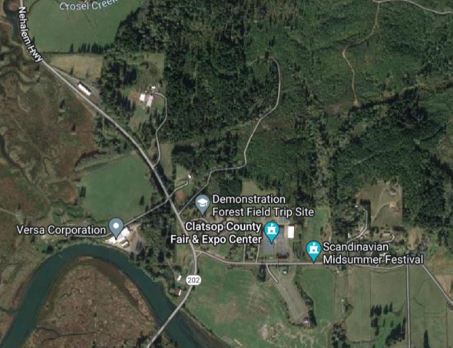
A double loop hike is offered - hike the Kwis Kwis Trail in one direction and return on the Fort to Sea Trail for a total distance of 7.3 miles and an elevation gain of 1125 feet . . . see Map
Some may prefer a shorter hike - just one loop for a total 4.2 miles (3.6 miles if you take the Connector).
Meet in the parking lot on Marine Drive between 2nd & 3rd Streets in Astoria at 9:00 a.m. or in the RV/overflow parking lot at the Fort Clatsop Visitor Center at 9:30 a.m. If you have one, please bring a National Park entry pass and let Dave know that you have one with you (1 Pass admits 4).
26 March
2:00 p.m.
11th & Harrison Streets in Astoria – Enter doorway on right

2 April
10:00 a.m.
Meet in front of the Captain Robert Gray School
785 Alameda Avenue in Astoria.

9 April
9:00 a.m.
Puget Island is located in the Columbia River in Wahkiakum County, Washington. We will drive 26 miles east along US-30 to Westport, Oregon. In Westport we board the Oscar B ferry for a ride to the south shore of Puget Island. The 12-minute ferry ride costs $6 per car and leaves Westport at quarter past the hour. Puget Island has 1100 residents and 8 square miles of houses, boats, sloughs and boat houses, farms, animals, roads, churches, but no stores or gas stations. It is interesting to drive around the island and see a different style of living and working. The bridge on the north shore of Puget Island crosses a water channel and leads to small town Cathlamet in Washington. Cathlamet offers interesting walks thru the town, by houses, parks, and cemeteries. Maria’s Mexican restaurant in Cathlamet and The Berry Patch restaurant in Westport are available if you are hungry.
We will meet on Saturday April 9 in the parking lot on Marine Drive between 2nd and 3rd at 9 a.m. and leave by 9:15 a.m. for Westport. Each car should have the $6 cash ready to give the ferry attendant en route. The cars can explore the island on their own and we can all meet at 12:00 noon in Cathlamet to walk and eat. Route 4 on the Washington side or US-30 on the Oregon side takes you back to Astoria.
Leader Dory Lukas, 907-302-1054
20 April
1:00 p.m.
led by Bill Herold . . . 503-468-0474
Hike consists of 2 loops less than ¾ mile total on a gentle trail.


1.91 miles, 1 hour 29 minutes, 238 feet elevation gain
30 April
9:00 a.m.
led by Arline LaMear . . . 503-338-6883
7 May
10:00 a.m.
Meet: NW corner of 15th & Exchange in Astoria
608-797-7753 or ericwheeler2◊gmail·com
14 May
9:00 a.m.
WET PLACES – Ponds, Marshes, Swamps
American Speedwell A.K.A Veronica (Veronica American)
Flavor is similar to watercress; the entire plant may be consumed. Also full of nutrients. As long as the water source is not contaminated. Salads, sautéed, or used like any green such as spinach.
Cattail (Typhaceae family)
Young shoots, when peeled down to its white core, may be steamed. They taste similarly to asparagus, and have lots of fiber.
Sphagnum Moss (Sphagnaceae)
Has antibiotic properties, construction uses and as wound dressings. During World War Two, in Britain, sphagnum moss was the official dressing of the British War Office. During this time, moss drives were held in the Pacific Northwest. Highly absorptive.
Sweet Gale (Myrcia gale)
Dried leaves and buds make a replacement for Bay Leaves. Use in small amounts, potent flavoring. Sweet Gale oil is used as an ingredient in Colognes.
Valerian (Valariana occidentalis)
Root used as a safe tea for anxiety and sleeplessness.
FORESTS AND OPEN WOODS
Alder Tree (Betulaceae alnus)
Smokes Salmon deliciously. High BTU firewood.
Hemlock Tree (Tsuga species)
Branch tips make a peasant tea high in Vitamin C.
Fern – Lady Fern(Anthyrium felix-femina) Ostrich (Matteuccia struthiopteris)
The first emergent coiled clusters of these fern are called Fiddleheads. They need to be cooked to be consumed. They can be pickled. Or dreg them in egg whites, then panko mixed with finely grated Asiago. Fry in olive oil.
Violets (Viola species)
Buds, leaves and flowers are tasty additions to salads.
Miner’s Lettuce, Candy Flower (Claytonia)
The common name of this edible is from how miners during the California gold rush, ate it to prevent scurvy. It’s loaded with vitamin C. Leaves and stem are great in salads, but after flowering, becomes bitter.
18 May
1:00 p.m.
led by Terry Arnall
503-861-3622
21 May
9:00 a.m.
led by John Markham
503-436-2310
30 May
9:00 a.m.
led by Arline LaMear . . . 503-338-6883
4 June
10:00 a.m.
Meet: Peter Pan Market, 7th & Niagara, Astoria
2.35 miles, 1 hour 44 minutes, 344 feet elevation gain
8 June
9:00 a.m.
led by Candia Elliott
503-320-1969
11 June
9:00 a.m.
led by Arline LaMear . . . 503-338-6883
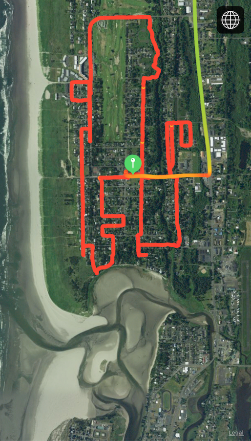
The Gearhart walk is mostly an urban walk. It follows the Ridge Path which is thought to be an old Indian trail. In the 1880’s, the Ridge Path was the principal byway through the dune meadows. We’ll be going by the first house built in Gearhart, erected in 1892. The earliest Gearhart homes were built along the path, an area which offered some protection from the often severe winter storms from the south. We’ll be going by McMenamin’s and the golf course. We’ll stop to enjoy the view of the Necanicum Estuary where 3 waterways – the Neacoxie, Neawanna, and the Necanicum flow into the Pacific Ocean. We’ll pass James Beard’s home – noted American chef and cookbook author. We’ll have views of the ocean but won’t be walking on the beach.
25 June
9:00 a.m.
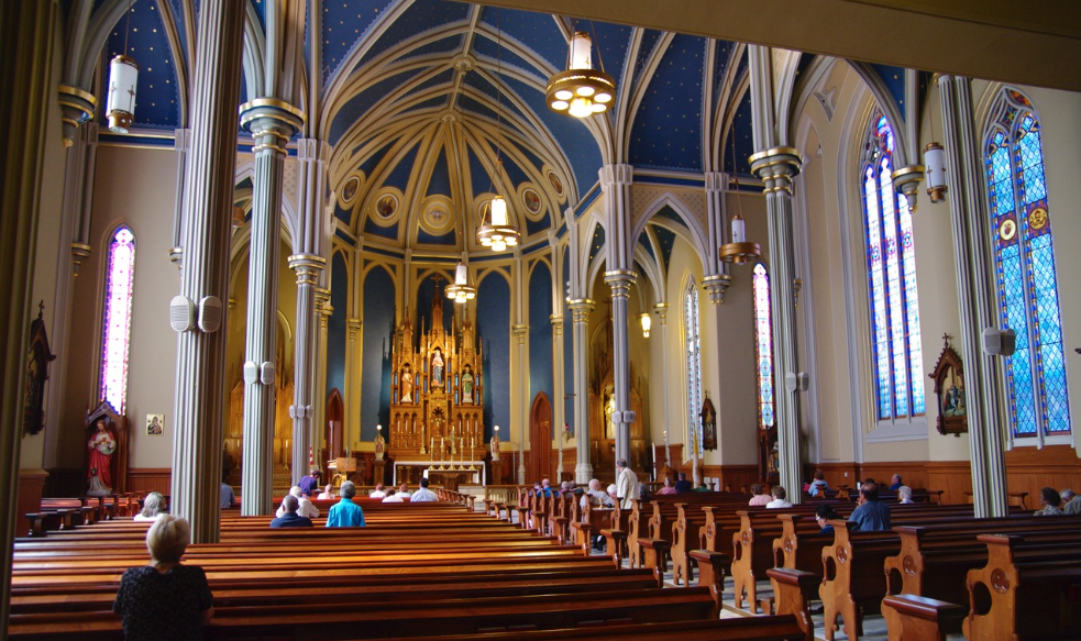
Ft. Vancouver National Historic Site tour
Arriving in Vancouver after a 95 mile drive from Astoria, a guided tour awaits of Sacred Art and Treasures of St James the Greater Cathedral, 218 West 12th Street at 11 a.m. This church was built in 15 months by employees of Hudson’s Bay Company in 1885 overlooking the Columbia River. The beauty, statues, paintings and architectural flourishes are linked to a powerful past and intended to inspire the glory of God. Its architectural features characterize a style called ‘Gothic Revival’. There are 2 choir lofts, interior pillars made of cedar and a floor of Spanish marble. The church’s original St. James bell was cast in Boston. Outstanding features inside are from all over the world. The first Vancouver Catholics worshipped in a wooden building at Ft. Vancouver destroyed by an arsonist in the 1870’s. Outside is a beautiful bronze statue of Our Lady of Vancouver dedicated in 2003. The building was restored in 2008, the piazza and outside grounds in 2015. It is breathtaking inside and beautifully restored, a local treasure.
Next is a stop at the Vancouver Saturday Market to buy a lunch if needed, then we’ll meet at the picnic tables at Fort Vancouver Historical Site, 1001 East 5th Street to eat lunch. There is a $10 fee if you do not have a NATIONAL PARKS LAND PASS. (good for 4 admissions). A Park Ranger will meet us at 1:00 for a guided tour of Ft. Vancouver. In 1825, the British Hudson’s Bay company built this Fort to serve as the center of a vast fur trading network. In 1849 it became the Northwest’s first U.S. Army Post. Learn about stories of Oregon Trail immigrants, a thriving air field, a massive lumber mill, and the diverse array of folks living here.
Reservations are requested if you plan to attend this event. Please call, email or text hike leader, Kathleen Hudson, 503-791-1392, khhudson12g@gmail.com by Wednesday, June 22. Your notice to attend is greatly appreciated. Kathleen will have a map of the Fort to give all who register.
6 July
1:00 p.m.
led by Eric Wheeler - 608-797-7753

2.21 miles, 2 hours 26 minutes, 483 feet elevation gain
9 July
12 noon
in Fort Stevens State Park - meet in Shelter A
There’s a parking fee. Arline LaMear 503-338-6883
20 July
1:00 p.m.
led by Jan Coughlin - 503-791-3521

4.61 miles, 2 hours 48 minutes, 558 feet elevation gain
23 July
9:00 a.m.
Reserve led by Jan Coughlin . . . 503-791-3521
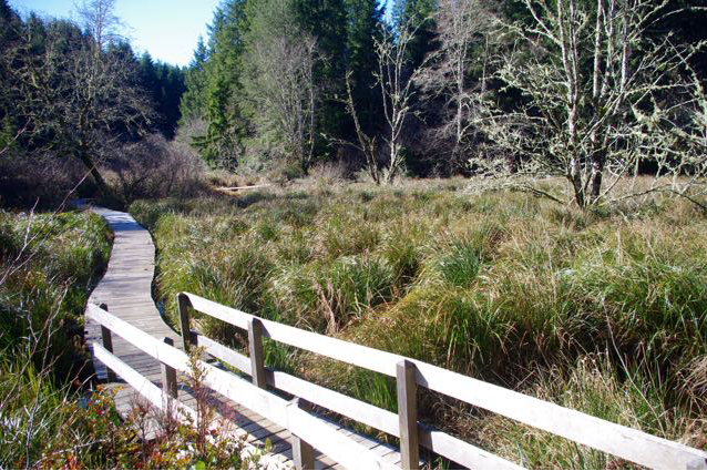
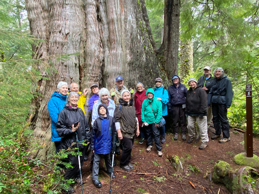
At 154 feet in height and almost 50 feet in circumference, Rockaway Beach’s magnificent old cedar resides amid a tiny remnant of coastal bog among other big spruce and cedar trees. Along this developed stretch of coastline, it’s a surprise to explore the dark interior of such a primeval swamp, 45 acres in all preserved in the Old Growth Cedar Wetlands Preserve.
In June 2019, a boardwalk was dedicated that allows visitors to walk from a trailhead on Highway 101 through the preserve to a viewing platform. From the platform, a trail leads to the tree. It's half a mile from the highway to the tree.

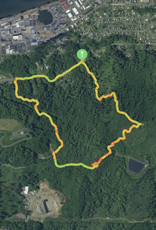
Kilchis Point Reserve – 10 miles south of Rockaway Beach: Encompassing about 200 acres near Tillamook Bay, Kilchis Point Reserve was once one of the largest Native American settlements on the northern Oregon coast, the home of Tillamook County’s first pioneer settler, and now a wetland preserve of important plant and animal wildlife. 2.1-mile loop trail near Bay City. The total miles for the day is 3.1 miles.
3 August
1:00 p.m.
led by Eric Wheeler - RSVP 608-797-7753
A 3 mile ramble featuring several hidden steps/staircases, great views and there will be history and architecture! We’ll end up with an optional beverage/food social gathering after the walk. A couple of steep ascents and descents on the walk, but nothing too strenuous. We’ll meet at the public parking area just SW of Englund Marine. Turn north off Marine Drive onto Hamburg Ave, go past Englund Marine, turn left and follow the street (turning to gravel) west to the parking area adjacent to the blacktop extension of the Waterfront trail. Should be plenty of parking...some of you could walk!
6 August
9:00 a.m.
led by Dan Vernon
571-263-2652
13 August
before noon
organized by Phuong Van Horn
503-791-5748
20 August
8:00 a.m.
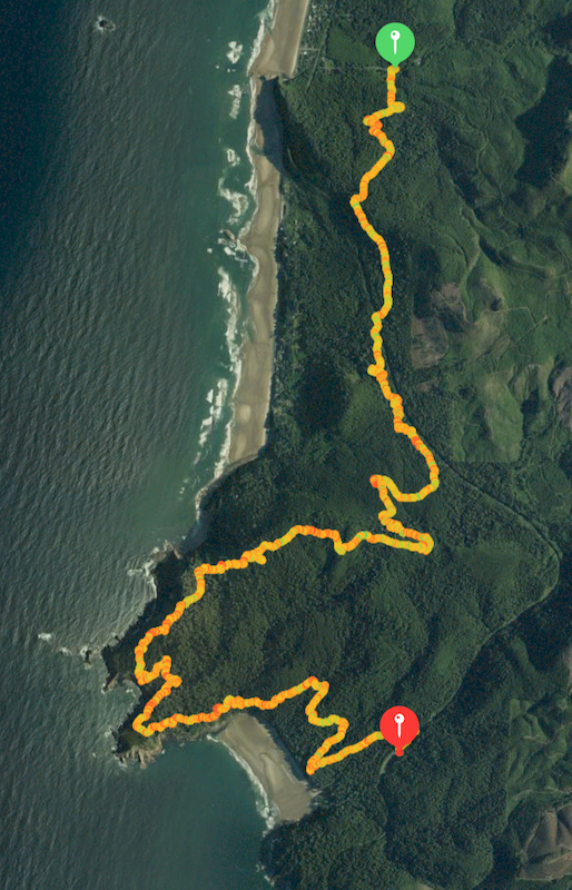
Distance 9.15 miles – Elevation gain 1689 feet – Time 6:17
To shorten this difficult hike, we will do a car shuttle. All cars will drive to the Short Sand Beach parking lot - we leave at 8 a.m. so we’ll find places to park. We’ll leave one half of the cars in the parking lot and everyone will get into the other half of the cars and drive north to the Arch Cape trail head. Upon completion of the hike at the Short Sand Beach parking lot, we’ll all get into the cars parked there and drive north to return to the cars parked in Arch Cape.
On this hike plan to walk out to Cape Falcon along the way and to spend a half an hour or so at Short Sand Beach (assuming it’s a sunny wonderful day) . . . . [skipped this year].

27 August
9:00 a.m.
led by Xia Amendolara - 503-553-9900
4.00 miles, 3 hours 40 minutes, 368 feet elevation gain
31 August
9:00 a.m.
led by Heather Simpson - 503-298-3418

3.24 miles, 3 hours 10 minutes, 165 feet elevation gain
7 September
1:00 p.m.
led by Ken Dell & Eric Wheeler - 608-797-7753
2.56 miles, 1 hour 47 minutes, 534 feet elevation gain
10 September
8:00 p.m.
led by Craig Holt
503-325-8207
21 September
9:00 a.m.
led by Bill Herold
425-737-3976
24 September
9:00 a.m.
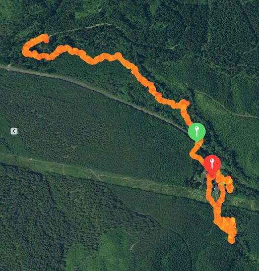
We’ll begin the hike at Council Crest Park (elevation 1,071 feet) in Portland because the parking is free and easy. The last few miles driving to Council Crest Park can be tricky. Set your navigation to 1120 SW Council Crest Drive, Portland, Oregon or to a nearby address if that doesn’t work.
When hiking go down Marquam and Shadyside trails to the Marquam Shelter, then up Connor trail to OHSU. In case the Tram is not available, this MAP will be helpful.
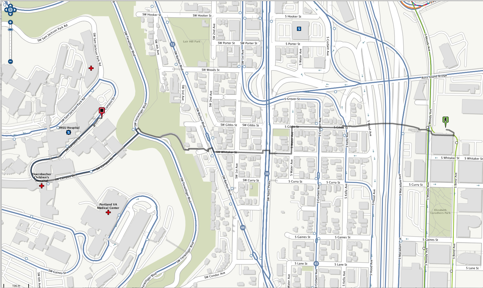
From start to finish: 4 hours . . . . Hiking distance: 6.5 miles, elevation gain 850 feet.
Bring a MASK - required in OHSU and on the tram.

8 October
1:00 p.m.
led by Phuong Van Horn
503-791-5748
16 October
10:00 a.m.
Eric Wheeler & Lower Columbia Preservation Society
meet at LCPS office - 389 12th Street in Astoria
22 October
3:00 p.m.
Astoria Senior Center
1111 Exchange Street in Astoria
29 October
10:00 a.m.
led by Eric Wheeler . . . 608-797-7753
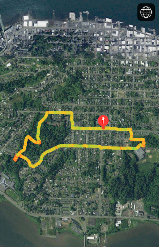
The Astor Court neighborhood is one of the oldest on Astoria’s South Slope. The extension of the electric streetcar into the neighborhood in 1915 sparked the development of the residential district along with a public school and two grocery stores. The Astor Court name can still be found on one of the grocery stores and a mid-century apartment building. We’ll take a walk up into the neighborhood to view the charming early 20th century blend of Craftsman, Colonial and Tudor Revival residential styles as well as a landmark mid-century-modern church.
The tour is mostly on level urban terrain but there are some off-road pathways that are steep in spots. Wear good walking shoes. The tour takes about 2 hours.
We’ll meet at the A-Town Coffee Shop (shown below) at 632 West Marine Drive at 10:00 a.m. If you are driving over, please park in the vacant lot just south-east of the coffee shop and north-west of the Napa Auto Parts store.

12 November
10:00 a.m.
led by Deborah Howe and Eric Wheeler
Another guided wander through Astoria’s ‘other side’. Some soft surface trails, 200' elevation gain, about 2 miles.
Please RSVP Eric Wheeler - ericwheeler2@gmail.com;
608-797-7753
19 November
9:00 a.m.
meet in the Shively Park parking area
We’re doing another of “Eric’s Ambles". This one will be led by Ken Dell and will follow Pipeline Road from one end to the other.
We’ll meet in the parking area of Shively Park at 9 a.m. (note the time) and carpool to Emerald Heights.
The hike from Emerald Heights to Shively Park is 3.6 miles overall - .8 mile through the housing on pavement and 2.8 miles along Navy Pipeline and Pipeline gravel roads through the forest. There is a 200' elevation gain, but it’s a fairly flat walk.
Please RSVP Ken Dell - kenjdell@gmail.com.
3 December
9:45 a.m.
starting at Skipanon River Park, 99 SE 3rd Ave.
There are two segments; one an out and back and the other a loop. Total distance is about 4.7 miles. There is a spot to opt out of the loop after doing the out and back first, which is the most scenic and semi-rural and is about 2.6 miles.
For those who want to meet at the starting point, plan to arrive at the Skipanon River Park at 10:00 am. The park is a small, out of the way park on the west side of the Skipanon River located at 99 SE 3rd Ave in Warrenton. There is parking for about 6 cars.
The “Eastern Spur’ of the trail, that is an out and back, should offer some good birding opportunities. Bring binoculars if that is your jam.
Totally flat trail; mostly dry, well packed surface.
We should arrive back at the Skipanon River Park around noon.
Please RSVP Eric Wheeler - ericwheeler2@gmail.com;
608-797-7753
10 December
10:00 a.m.
beginning & ending at Shively Park to work up an
Saturday's hike will begin at Shively Park, so meet there at 10 a.m. From there we'll walk to the south side of the park and then hike toward Eagle Ridge. At the Powerline, we'll go down and cross Williamsport Road to the high school football field, climb an embankment to the Bonneville Powerline Road. We'll follow Powerline to a forest trail which links to Pipeline Road, then back to Williamsport and Shively Park. The hike is 3.8 miles with a 360' elevation gain. There is one steep climb at the football field and possible water/slush at Brown Creek on Powerline, so walking sticks could be helpful.
10 December
2:00 p.m.
1111 Exchange – Bring your favorite dish & your
own beverage. We’ll provide the paper products.
17 December
10:00 a.m.
Park (near Cedar and 45th Streets).
Eric Wheeler will be leading a walk in the Alderbrook neighborhood. Meet at LaPlante Park (near Cedar Street and 45th Street) then we’ll head east into the neighborhood. We’ll maintain a good pace but we’ll stop from time to time to look at buildings and surroundings. About 2 miles in about 2 hours. Hard surface streets and sidewalks with minimal elevation gain. Plan to be back to the starting point around noon.
Please RSVP Eric Wheeler - ericwheeler2@gmail.com;
608-797-7753
31 December
10:00 a.m.
Wheeler [RSVP 608-797-7753]. Meet at the
Astoria Coffee House & Bistro - 243 11th Street
8 January
2:00 p.m.
Conference Room 231, 2001 Marine Drive,
Astoria - led by the Chief Guide
For additions and changes to this schedule:
attend meetings,
read your e-mail, look above 🙄 and/or check the “Community
Notes” in The Astorian newspaper on Thursday.
On all hikes stay together, follow the leader & stay ahead of the
“sweep”. Notify the sweep if you’re leaving the group.
Dues are $10 per calendar year, best paid by February 15.
— Membership not required to hike with the Club. —
No dogs are allowed on Angora Hiking Club hikes/walks.
— kids and old goats are permitted —
President Craig Holt
503-325-8207 craig·holt◊me·com
Vice-President Dory Lukas
907-302-1054 dorenelukas◊gmail·com
Chief Guide Arline LaMear
503-338-6883 cliffandarline◊msn·com
Secretary Terry Arnall
503-861-3622 tarnall181◊gmail·com
Treasurer Jeanne Hyatt
503-861-0201 jandjhyatt◊msn·com
Facebook Betty Pecchio
503-784-5612 bpecchio◊hotmail·com
Angora Hiking Club
Post Office Box 1212
Astoria OR 97103